# 插入网格点(interpolate)

> npm install @turf/interpolate

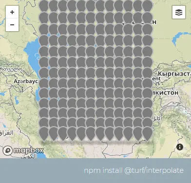
Takes a set of points and estimates their 'property' values on a grid using the Inverse Distance Weighting (IDW) method. 接收一组点要素集,使用 反向距离加权(IDW) (opens new window) (opens new window)方法估算并返回要素集。

参数

参数 类型 描述
points FeatureCollection <Point> 传入的要素集
cellSize number 每个网格点之间的距离
options Object 可配置项

options 选项

属性 类型 默认值 描述
gridType string "square" 出参要素集的要素类型,可选值有:"square"(矩形)、"point"(点)、"hex"(六边形)、"triangle"(三角形)
property string "elevation" 参与计算的属性
units string "kilometers" 单位,可选的有 degrees、radians、miles、kilometers
weight number 1 调节距离衰减权重的指数

返回

FeatureCollection <(Point|Polygon)> - grid of points or polygons with interpolated 'property'

FeatureCollection <(Point|Polygon)> - 具有插值“属性”的点或多边形网格

示例

var points = turf.randomPoint(30, { bbox: [50, 30, 70, 50] });

// add a random property to each point
turf.featureEach(points, function (point) {
  point.properties.solRad = Math.random() * 50;
});
var options = { gridType: "points", property: "solRad", units: "miles" };
var grid = turf.interpolate(points, 100, options);

img

基础用法

打开
<template>
  <base-map :zoom="1">
  <a-button
      type="primary"
      @click="
        () => {
          visible = true;
        }
      "
      >打开</a-button
    >
    <drawer :visible.sync="visible" :code="code">
      <a-row>
        <a-space><json :data="result" /></a-space>
      </a-row>
    </drawer>
    <vue2ol-layer-vector :zIndex="20" v-if="features">
      <vue2ol-source-vector :features="features"> </vue2ol-source-vector>
    </vue2ol-layer-vector>
  </base-map>
</template>
<script>
import * as turf from "@turf/turf";
import { GeoJSON } from "ol/format";
export default {
  data() {
    return {
      coordinate: null,
      features: null,
      result: null,
      visible:true
    };
  },
    computed:{
    code(){
        return `var points = turf.randomPoint(30, { bbox: [50, 30, 70, 50] });
// add a random property to each point
turf.featureEach(points, function (point) {
  point.properties.solRad = Math.random() * 50;
});
var options = { gridType: "points", property: "solRad", units:"miles" };
var grid = turf.interpolate(points, 100, options);`
    }
  },
  mounted() {
    var points = turf.randomPoint(30, { bbox: [50, 30, 70, 50] });
    // add a random property to each point
    turf.featureEach(points, function (point) {
      point.properties.solRad = Math.random() * 50;
    });
    var options = { gridType: "points", property: "solRad", units: "miles" };
    this.result = turf.interpolate(points, 100, options);

    this.features = new GeoJSON().readFeatures(this.result);
  },
  methods: {},
};
</script>
Expand Copy

动态设置

打开 绘制点(未激活) 每个网格点之间的距离(cellSize): 出参要素集的要素类型(gridType): 参与计算的属性(property): 单位(units): 调节距离衰减权重的指数(weight): 确定
<template>
  <base-map :zoom="1">
    <a-button
      type="primary"
      @click="
        () => {
          visible = true;
        }
      "
      >打开</a-button
    >
    <drawer :visible.sync="visible" :code="code">
      <a-row>
        <a-space
          ><a-button type="primary" @click="handleDrawPoint"
            >绘制点({{ isDrawPoint ? "激活" : "未激活" }})</a-button
          ></a-space
        >
      </a-row>
      <a-row>
        <a-space
          >每个网格点之间的距离(cellSize):<a-input-number
            v-model="cellSize"
          ></a-input-number
        ></a-space>
      </a-row>
      <a-row>
        <a-space
          >出参要素集的要素类型(gridType):<grid-type
            :value.sync="gridType"
          ></grid-type
        ></a-space>
      </a-row>
      <a-row>
        <a-space
          >参与计算的属性(property):<a-input v-model="property"></a-input
        ></a-space>
      </a-row>
      <a-row>
        <a-space
          >单位(units):<length-units :value.sync="units"></length-units
        ></a-space>
      </a-row>
      <a-row>
        <a-space
          >调节距离衰减权重的指数(weight):<a-input-number
            v-model="weight"
          ></a-input-number
        ></a-space>
      </a-row>

      <a-row>
        <a-button type="primary" @click="handleSure">确定</a-button>
      </a-row>
      <a-row>
        <a-space><json :data="result" /></a-space>
      </a-row>
    </drawer>
    <vue2ol-layer-vector @ready="handleReadyDrawLayer">
      <vue2ol-source-vector>
        <vue2ol-interaction-draw
          :active="isDrawPoint"
          type="Point"
          @drawend="handleDrawEnd"
        ></vue2ol-interaction-draw>
      </vue2ol-source-vector>
    </vue2ol-layer-vector>
    <vue2ol-layer-vector :zIndex="20" v-if="features">
      <vue2ol-source-vector :features="features"> </vue2ol-source-vector>
    </vue2ol-layer-vector>
  </base-map>
</template>
<script>
import * as turf from "@turf/turf";
import { GeoJSON } from "ol/format";
export default {
  data() {
    return {
      isDrawPoint: false,
      drawLayer: null,
      cellSize: 100,
      gridType: "square",
      units: "kilometers",
      weight: 1,
      property: "elevation",

      visible: true,
      features: null,
      result: null,
      drawFeatures: null,
    };
  },
  computed: {
    code() {
      if (!this.drawFeatures) {
        return "";
      }
      return `let grid = turf.interpolate(
  ${new GeoJSON().writeFeatures(this.drawFeatures)},
  ${this.cellSize},
  {
    gridType: '${this.gridType}',
    property: '${this.property}',
    units: '${this.units}',
    weight: ${this.weight},
  }
);`;
    },
  },
  mounted() {},
  methods: {
    handleSure() {
      this.result = turf.interpolate(
        JSON.parse(new GeoJSON().writeFeatures(this.drawFeatures)),
        this.cellSize,
        {
          gridType: this.gridType,
          property: this.property,
          units: this.units,
          weight: this.weight,
        }
      );
      this.features = new GeoJSON().readFeatures(this.result);
      console.log(this.features);
    },
    handleDrawPoint() {
      this.isDrawPoint = true;
    },
    handleReadyDrawLayer(mapObject) {
      this.drawLayer = mapObject;
    },
    handleDrawEnd(e) {
      e.feature.set(this.property, Math.random() * 50);
      this.drawFeatures = this.drawLayer.getSource().getFeatures();
    },
  },
};
</script>
Expand Copy