# 计算两点间角度(bearing)

> npm install @turf/bearing

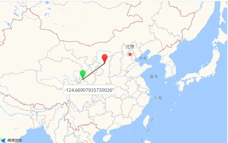
Takes two points and finds the geographic bearing between them, i.e. the angle measured in degrees from the north line (0 degrees)

接收两个点类型的 GeoJSON,计算获取二者之间的地理方位,并与正北方向所形成的角度(0 度)

即以起始点为参照物,终止点的偏移角度

参数

参数 类型 描述
start Coor 起始点,即作为参照物的点
end Coor 终止点,即要对比计算的点
options Object 可配置项

options 选项

属性 类型 默认值 描述
final boolean false 为 true 只计算最终轴承,即返回的数值介于 0 至 360 之间

返回

number - bearing in decimal degrees, between -180 and 180 degrees (positive clockwise)

number - 如果 final 为 false,返回的数值介于 -180 至 180 之间,顺时针为正值,否则返回的数值介于 0 至 360 之间

示例

var point1 = turf.point([-75.343, 39.984]);
var point2 = turf.point([-75.534, 39.123]);

var bearing = turf.bearing(point1, point2); // -170.2330491349224
var bearing = turf.bearing(point1, point2, { final: true }); // 189.6453188611693

// 也可以用经纬度坐标
var bearing = turf.bearing([-75.343, 39.984], [-75.534, 39.123]); // -170.2330491349224

image-20221108114651670

基础用法

打开
<template>
  <base-map>
    <a-button
      type="primary"
      @click="
        () => {
          visible = true;
        }
      "
      >打开</a-button
    >
    <drawer :visible.sync="visible" :code="code">
      <a-row> {{ value }}</a-row>
    </drawer>
    <vue2ol-layer-vector>
      <vue2ol-source-vector>
        <vue2ol-feature :style-obj="startStyle">
          <vue2ol-geom-point
            :coordinates="startCoordinates"
          ></vue2ol-geom-point>
        </vue2ol-feature>
        <vue2ol-feature :style-obj="endStyle">
          <vue2ol-geom-point :coordinates="endCoordinates"></vue2ol-geom-point>
        </vue2ol-feature>
      </vue2ol-source-vector>
    </vue2ol-layer-vector>
  </base-map>
</template>
<script>
import * as turf from "@turf/turf";
import { GeoJSON } from "ol/format";
import { Style, Stroke, Text, Circle, Fill } from "ol/style";
export default {
  data() {
    return {
      startCoordinates: [119.76160526275636, 27.91434097290039],
      endCoordinates: [120.11316776275636, 28.11209487915039],
      value: null,
      startStyle: null,
      endStyle: null,
      visible: true,
    };
  },
  computed: {
    code() {
      return `let result = turf.bearing(
  turf.point(${JSON.stringify(this.startCoordinates)}),
  turf.point(${JSON.stringify(this.endCoordinates)})
);`;
    },
  },
  mounted() {
    this.startStyle = new Style({
      image: new Circle({
        stroke: new Stroke({
          color: "#ff0000",
          width: 2,
        }),
        radius: 4,
      }),
      text: new Text({
        text: "起点",
        overflow: true,
        fill: new Fill({
          color: "#ffffff",
        }),
        font: "20px sans-serif",
      }),
    });
    this.endStyle = new Style({
      image: new Circle({
        stroke: new Stroke({
          color: "#ff0000",
          width: 2,
        }),
        radius: 4,
      }),
      text: new Text({
        text: "终点",
        overflow: true,
        fill: new Fill({
          color: "#ffffff",
        }),
        font: "20px sans-serif",
      }),
    });
    this.value = turf.bearing(
      turf.point(this.startCoordinates),
      turf.point(this.endCoordinates)
    );
  },
};
</script>
Expand Copy

动态绘制

打开 绘制起点 绘制终点
<template>
  <base-map>
    <a-button
      type="primary"
      @click="
        () => {
          visible = true;
        }
      "
      >打开</a-button
    >
    <drawer :visible.sync="visible" :code="code">
      <a-row
        ><a-button type="primary" @click="handleStart"
          >绘制起点</a-button
        ></a-row
      >
      <a-row
        ><a-button type="primary" @click="handleEnd">绘制终点</a-button></a-row
      >
      <a-row> {{ value }}</a-row>
    </drawer>
    <vue2ol-layer-vector :style-obj="startStyle">
      <vue2ol-source-vector @ready="handleReadyStartSource">
        <vue2ol-interaction-draw
          type="Point"
          :active="isDrawStart"
          @drawend="handleDrawEndStart"
        ></vue2ol-interaction-draw>
      </vue2ol-source-vector>
    </vue2ol-layer-vector>

    <vue2ol-layer-vector :style-obj="endStyle">
      <vue2ol-source-vector @ready="handleReadyEndSource">
        <vue2ol-interaction-draw
          type="Point"
          :active="isDrawEnd"
          @drawend="handleDrawEndEnd"
        ></vue2ol-interaction-draw>
      </vue2ol-source-vector>
    </vue2ol-layer-vector>
  </base-map>
</template>
<script>
import * as turf from "@turf/turf";
import { GeoJSON } from "ol/format";
import { Style, Stroke, Text, Circle, Fill } from "ol/style";
export default {
  data() {
    return {
      isDrawEnd: false,
      isDrawStart: false,
      value: null,
      startStyle: null,
      endStyle: null,
      startGeometry: null,
      endGeometry: null,
      startSource: null,
      endSource: null,
      visible: true,
    };
  },
  watch: {
    startGeometry() {
      this.init();
    },
    endGeometry() {
      this.init();
    },
  },
  computed: {
    code() {
      if (!this.startGeometry || !this.endGeometry) {
        return;
      }
      return `let result = turf.bearing(
  turf.point(${JSON.stringify(this.startGeometry.getCoordinates())}),
  turf.point(${JSON.stringify(this.endGeometry.getCoordinates())}),
  { final: true }
);`;
    },
  },
  mounted() {
    this.startStyle = new Style({
      image: new Circle({
        stroke: new Stroke({
          color: "#ff0000",
          width: 2,
        }),
        radius: 4,
      }),
      text: new Text({
        text: "起点",
        overflow: true,
        fill: new Fill({
          color: "#ffffff",
        }),
        font: "20px sans-serif",
      }),
    });
    this.endStyle = new Style({
      image: new Circle({
        stroke: new Stroke({
          color: "#ff0000",
          width: 2,
        }),
        radius: 4,
      }),
      text: new Text({
        text: "终点",
        overflow: true,
        fill: new Fill({
          color: "#ffffff",
        }),
        font: "20px sans-serif",
      }),
    });
  },
  methods: {
    init() {
      if (!this.startGeometry || !this.endGeometry) {
        return;
      }
      this.value = turf.bearing(
        turf.point(this.startGeometry.getCoordinates()),
        turf.point(this.endGeometry.getCoordinates()),
        { final: true }
      );
    },
    handleStart() {
      this.isDrawStart = !this.isDrawStart;
      this.isDrawEnd = false;
    },
    handleEnd() {
      this.isDrawEnd = !this.isDrawEnd;
      this.isDrawStart = false;
    },
    handleDrawEndStart(e) {
      this.startSource.clear();
      this.startGeometry = e.feature.getGeometry();
    },
    handleDrawEndEnd(e) {
      this.endSource.clear();
      this.endGeometry = e.feature.getGeometry();
    },
    handleReadyStartSource(mapObject) {
      console.log(mapObject);
      this.startSource = mapObject;
    },
    handleReadyEndSource(mapObject) {
      this.endSource = mapObject;
    },
  },
};
</script>
Expand Copy